Circle processor
Converts circle definitions of shapes to regular polygons which approximate them.
| Name | Required | Default | Description |
|---|---|---|---|
field |
yes | - | The field to interpret as a circle. Either a string in WKT format or a map for GeoJSON. |
target_field |
no | field |
The field to assign the polygon shape to, by default field is updated in-place |
ignore_missing |
no | false |
If true and field does not exist, the processor quietly exits without modifying the document |
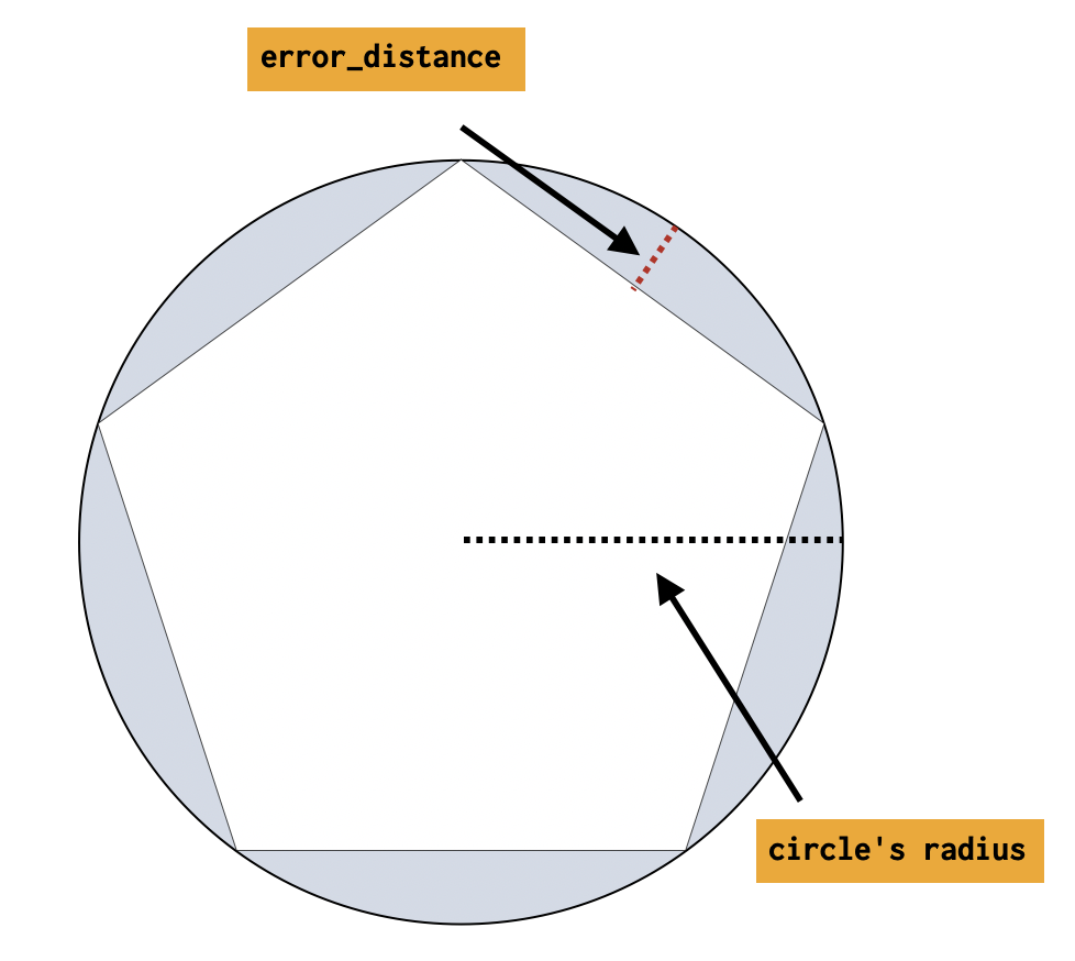
error_distance |
yes | - | The difference between the resulting inscribed distance from center to side and the circle’s radius (measured in meters for geo_shape, unit-less for shape) |
shape_type |
yes | - | Which field mapping type is to be used when processing the circle: geo_shape or shape |
description |
no | - | Description of the processor. Useful for describing the purpose of the processor or its configuration. |
if |
no | - | Conditionally execute the processor. See Conditionally run a processor. |
ignore_failure |
no | false |
Ignore failures for the processor. See Handling pipeline failures. |
on_failure |
no | - | Handle failures for the processor. See Handling pipeline failures. |
tag |
no | - | Identifier for the processor. Useful for debugging and metrics. |
PUT circles {
"mappings": {
"properties": {
"circle": {
"type": "geo_shape"
}
}
}
}
PUT _ingest/pipeline/polygonize_circles
{
"description": "translate circle to polygon",
"processors": [
{
"circle": {
"field": "circle",
"error_distance": 28.0,
"shape_type": "geo_shape"
}
}
]
}
Using the above pipeline, we can attempt to index a document into the circles index. The circle can be represented as either a WKT circle or a GeoJSON circle. The resulting polygon will be represented and indexed using the same format as the input circle. WKT will be translated to a WKT polygon, and GeoJSON circles will be translated to GeoJSON polygons.
Circles that contain a pole are not supported.
In this example a circle defined in WKT format is indexed
PUT circles/_doc/1?pipeline=polygonize_circles {
"circle": "CIRCLE (30 10 40)"
}
GET circles/_doc/1
The response from the above index request:
{
"found": true,
"_index": "circles",
"_id": "1",
"_version": 1,
"_seq_no": 22,
"_primary_term": 1,
"_source": {
"circle": "POLYGON ((30.000365257263184 10.0, 30.000111397193788 10.00034284530941, 29.999706043744222 10.000213571721195, 29.999706043744222 9.999786428278805, 30.000111397193788 9.99965715469059, 30.000365257263184 10.0))"
}
}
In this example a circle defined in GeoJSON format is indexed
PUT circles/_doc/2?pipeline=polygonize_circles {
"circle": {
"type": "circle",
"radius": "40m",
"coordinates": [30, 10]
}
}
GET circles/_doc/2
The response from the above index request:
{
"found": true,
"_index": "circles",
"_id": "2",
"_version": 1,
"_seq_no": 22,
"_primary_term": 1,
"_source": {
"circle": {
"coordinates": [
[
[30.000365257263184, 10.0],
[30.000111397193788, 10.00034284530941],
[29.999706043744222, 10.000213571721195],
[29.999706043744222, 9.999786428278805],
[30.000111397193788, 9.99965715469059],
[30.000365257263184, 10.0]
]
],
"type": "Polygon"
}
}
}
Accuracy of the polygon that represents the circle is defined as error_distance. The smaller this difference is, the closer to a perfect circle the polygon is.
Below is a table that aims to help capture how the radius of the circle affects the resulting number of sides of the polygon given different inputs.
The minimum number of sides is 4 and the maximum is 1000.
| error_distance | radius in meters | number of sides of polygon |
|---|---|---|
| 1.00 | 1.0 | 4 |
| 1.00 | 10.0 | 14 |
| 1.00 | 100.0 | 45 |
| 1.00 | 1000.0 | 141 |
| 1.00 | 10000.0 | 445 |
| 1.00 | 100000.0 | 1000 |